

Fitxer:Italy 1000 AD.svg

Mida d'aquesta previsualització PNG del fitxer SVG: 418 × 600 píxels. Altres resolucions: 167 × 240 píxels | 334 × 480 píxels | 535 × 768 píxels | 713 × 1.024 píxels | 1.427 × 2.048 píxels | 565 × 811 píxels.
Fitxer original (fitxer SVG, nominalment 565 × 811 píxels, mida del fitxer: 861 Ko)

Aquest fitxer i la informació mostrada a continuació provenen del dipòsit multimèdia lliure Wikimedia Commons.
 Vegeu la pàgina original a Commons
 Vegeu la pàgina original a Commons


Resum
| Descripció |
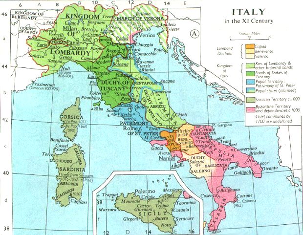
English: Political map of Italy in 1000 AD (CE). Created by MapMaster.
Part of a series of maps on the history of Italy:
|
| Data | 17 de novembre de 2006 (original upload date) |
| Font | No machine-readable source provided. Own work assumed (based on copyright claims). |
| Autor | No machine-readable author provided. MapMaster assumed (based on copyright claims). |
| Altres versions |
[] SVG:
PNG:
|


|
Aquest fitxer SVG inclou text encapsulat que es pot traduir al vostre idioma utilitzant un editor que admeti SVG, un editor de text o l'eina de traducció de SVG. Per a més informació vegeu l'ajuda de traducció de fitxers SVG. |

References
- Bjorklund, Oddvar; Holmboe, Haakon; Rohr, Anders (1970) Historical Atlas of the World, Barnes & Noble, NY, SBN: 389-00253-4.
- This map from Allyn & Bacon, Longman, textbook publishers.
- This map of the w:en:Holy Roman Empire
- A map from Attilios
- This map of 1050 AD Italy, from the 1923 The Historical Atlas by William R. Shepherd
- This map of 1000 AD Italy from Fordham University, adapted from Muir's Historical Atlas, (1911).


In addition, a number of other sources were consulted in an effort to determine the following matters:
- The extent of Venetian control over the cities of Dalmatia such as Zara and Spalato. Although the Venetians had been pushed off the mainland earlier, in the period around the year 1000, the Venetians made an effort to recover these cities.
- The extent of Saracen control over Corsica and Sardinia. Information is sparse. The apparent situation is that the Muslims had several bases on the coasts of these islands, but did not control the countryside (such as they did in Sicily).
- Whether or not the principalities of Capua and Benevento were separate states in the year 1000. Based on lists of their rulers (various Pandulfs and Landulfs), the answer seems to be "yes".
- Who controlled the Balkans on the southeastern border of the Kingdom of Croatia. Candidates include Bulgaria, the Byzantine Empire, Croatia, and Serbia.
As noted, there is significant disagreement among sources on these questions.
This map was commissioned by Attilios, and there is also a discussion to be found on MapMaster's English talk page.
Llicència
Jo, el titular dels drets d'autor d'aquest treball, el public sota la següent llicència:

|
S'autoritza la còpia, la distribució i la modificació d'aquest document sota els termes de la llicència de documentació lliure GNU versió 1.2 o qualsevol altra versió posterior que publiqui la Free Software Foundation; sense seccions invariants, ni textos de portada, ni textos de contraportada. S'inclou una còpia d'aquesta llicència en la secció titulada GNU Free Documentation License. |
  
|
Aquest fitxer està subjecte a la llicència Creative Commons Reconeixement-CompartirIgual 3.0 No adaptada. | |
| ||
| Aquest avís de llicència s'ha afegit a aquest fitxer d'acord amb l'actualització de la llicència GFDL. |
derivative works
Derivative works of this file: Italya MS 1000.svg
Historial del fitxer
Cliqueu una data/hora per veure el fitxer tal com era aleshores.
| Data/hora | Miniatura | Dimensions | Usuari/a | Comentari | |
|---|---|---|---|---|---|
| actual | 21:50, 17 abr 2007 | | 565 × 811 (861 Ko) | wikimediacommons>MapMaster | Some further changes |
Ús del fitxer
La pàgina següent utilitza aquest fitxer:
