

Fitxer:Kalmykia03.png

Mida d'aquesta previsualització: 680 × 600 píxels. Altres resolucions: 272 × 240 píxels | 544 × 480 píxels | 738 × 651 píxels.
Fitxer original (738 × 651 píxels, mida del fitxer: 44 Ko, tipus MIME: image/png)

Aquest fitxer i la informació mostrada a continuació provenen del dipòsit multimèdia lliure Wikimedia Commons.
 Vegeu la pàgina original a Commons
 Vegeu la pàgina original a Commons


Resum
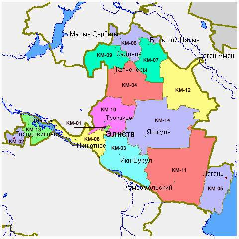
- Map of the Republic of Kalmykia.
Source and license

|
This map has been uploaded by Electionworld from en.wikipedia.org to enable the  Wikimedia Atlas of the World . Original uploader to en.wikipedia.org was PANONIAN, known as PANONIAN at en.wikipedia.org. Electionworld is not the creator of this map. Licensing information is below. |
Map made by PANONIAN

|
S'ha alliberat aquesta obra al domini públic pel seu autor PANONIAN. Això s'aplica a tot el món. En alguns països això pot no ser legalment possible, en tal cas: |
References
Maps of Kalmykia:
- http://www.mapzones.com/citymap/russia/republic_of_kalmykia/republic_of_kalmykia.jpg
- http://www.eatingahobo.com/kalmykia01.gif archive copy at the Wayback Machine
- https://www.usrbc.org/pics/Image/Russian%20Regions/Kalmykia%20Republic/map_kalmyk.gif
- http://www.zum.de/whkmla/histatlas/russia/kalmykia.gif
- http://www.rdaward.org/map/6i.jpg
- http://farm4.static.flickr.com/3050/3255735175_fd4c1a7b79.jpg
- http://files.vector-images.com/clipart/kalmykia_map.gif archive copy at the Wayback Machine
- http://farm3.staticflickr.com/2358/2163150592_33a3152774.jpg
- http://www.regions.newsall.ru/kalmykia/kalmykia.htm.gif
- http://www.tatneft.ru/wps/wcm/jsp/getImage.jsp?content_id=com.ibm.workplace.wcm.api.WCM_Content/news_2009.05.12_16.18.03.669/db640a804e13769483b6b7f586c5a29c/PUBLISHED&name=image[dead link]




Largest settlements in Kalmykia:
- http://world-gazetteer.com/wg.php?x=&men=gcis&lng=en&des=wg&geo=-183&srt=npan&col=abcdefghinoq&msz=1500&geo=-3118[dead link]
Historial del fitxer
Cliqueu una data/hora per veure el fitxer tal com era aleshores.
| Data/hora | Miniatura | Dimensions | Usuari/a | Comentari | |
|---|---|---|---|---|---|
| actual | 12:48, 14 maig 2012 | | 738 × 651 (44 Ko) | wikimediacommons>WikiEditor2004 | Reverted to version as of 09:07, 14 May 2012 - trying to fix thumbnail problem once more |
Ús del fitxer
La pàgina següent utilitza aquest fitxer:
